About British Columbia, Canada
Last updated: March 25, 2026British Columbia is Canada's westernmost province, situated between the Pacific Ocean and the Rocky Mountains. The province is known for its diverse natural landscapes, which include rugged coastlines, lush rainforests, and majestic mountains and glacial lakes. With a population of over 5 million, its capital city is Victoria, and its largest city is Vancouver.
To learn more about British Columbia, Canada, see the topics below.
Indigenous Peoples
Indigenous Peoples are people who lived on this land long before Europeans came. Currently, there are close to 2 million Indigenous Peoples in Canada, and more than 600 First Nations. More than 200 of these First Nations are in British Columbia. Most Indigenous Peoples in B.C. do not live in Indigenous communities; they live in towns and cities across the province.
The people who are Indigenous to Canada belong to 3 groups: First Nations, Métis, and Inuit.
- First Nations people have lived in B.C. since time immemorial, which means before memory or record. Hundreds of thousands of First Nations people were here when Europeans came to B.C. in the mid-1700s.
- The Métis people are of mixed European and First Nations ancestry. They are a distinct people and Nation.
- Inuit are Indigenous people of the Arctic.
There are many stereotypes and prejudices toward the people who are indigenous to Canada. This comes from the history of how European settlers treated the Indigenous Peoples.
Indigenous Peoples and European history
Long before the first Europeans came to North America, First Nations had their own government, laws, traditions, and economies. They had (and still have) their own languages, ceremonies, traditions, cultures, and spiritual beliefs.
When English, French, and Spanish explorers arrived in North America, their countries were fighting for power and control over land all around the world. Many of the settlers here did not respect Indigenous Peoples, their laws, governments, cultures, beliefs, or relationships.
In 1867, the Government of Canada was formed. It created the Indian Act, which came into effect in 1876. The Indian Act applies only to status Indians, and has not historically recognized Métis and Inuit Peoples. As a result, the Métis and Inuit have not had Indian status and the rights conferred by this status despite being Indigenous to Canada and participating in Canadian nation building. The Indian Act controls every part of First Nation life. It also tries to erase their cultures and ways of life. Indigenous Peoples have always resisted the Indian Act and colonization, and have fought for their rights. Amnesty International, the United Nations, and the Canadian Human Rights Commission have called the Indian Act a “human rights abuse”.
One of the worst things in the colonial history of Canada was residential schools, which tried to destroy the culture of First Nations, Métis, and Inuit Peoples. Approximately 150,000 Indigenous children were forcibly removed from their homes and families. They were sent to live in schools far away from home. They were forced to learn English and were not allowed to use their language or practice their culture. Children suffered terrible abuses at the schools, and many died. The last residential school closed in 1996.
The lasting damage and trauma caused by residential schools—and many other examples of racism and unfairness in Canada’s history—still affects Indigenous Peoples, families, and communities today. It also affects Canada as a country.
Recent history and reconciliation
The federal and provincial governments are beginning to see how their actions have hurt First Nations, Métis, and Inuit Peoples. In 2008, the Government of Canada created the Truth and Reconciliation Commission to begin to look at and recognize the injustices against Indigenous Peoples across the country. For more information, visit The National Centre for Truth and Reconciliation website.
In 2007, the United Nations General Assembly adopted the United Nations Declaration on the Rights of Indigenous Peoples (UN Declaration, or UNDRIP). The UN Declaration has been adopted by 148 nations. It recognizes Indigenous Peoples’ rights to live in dignity; to maintain and strengthen Indigenous institutions, cultures, and traditions; and to decide their own future in line with Indigenous needs and goals.
In November 2019, the B.C. government passed the Declaration on the Rights of Indigenous Peoples Act to implement the UN Declaration provincially. This means the B.C. government recognizes and respects the human rights of Indigenous Peoples. Learn about the work the government is doing with Indigenous Peoples to help build a better future for Indigenous Peoples and everyone in B.C.
Indigenous Peoples today
The Government of Canada tried to destroy Indigenous Peoples’ connections to culture, traditions, economies, laws, and rights to the land. But those connections remain strong today. Indigenous peoples are rebuilding cultures and languages that were almost lost. Many children are raised to be proud of who they are. Many First Nations communities welcome non- Indigenous people to cultural festivals and celebrations such as powwows. Powwows are traditional gatherings that include singing, dancing, food, crafts, and reconnecting with old friends. Find a powwow in B.C.
Some First Nations leadership is hereditary (based on family). Under the Indian Act, the Canadian government created “bands”—a new kind of leadership that ignored the First Nations’ tradition. It meant the Government of Canada—not the First Nation—decided who could be a member of the band. Many bands now have an elected council, called a “band council”, which elects a Chief. Some bands have both hereditary and elected Chiefs, leaders, and Matriarchs (women leaders). Elected band councils manage education, band schools, housing, water and sewer systems, roads, and other community businesses and services.
Some First Nations communities have self- government agreements. Self-government means First Nations can take control of decisions and make their own laws. They can decide how to raise and spend money, deliver programs, and create jobs and economic opportunities.
In most parts of Canada, the British Crown established treaties with First Nations before Canada was formed. Canada continued this policy of making treaties before the west was opened up for settlement, but in B.C. this process was never completed. Today, you may hear someone begin an event by saying, “We would like to acknowledge the territory of the Coast Salish people”. This recognizes that First Nations people did not give up their land or legally sign it away to Britain or Canada. Acknowledging a territory or language group you are on is also one way to honour the Indigenous Peoples and their histories present on the land.
Most people in Canada do not know much about Indigenous Peoples, their histories, cultures, and ways of living. There are many reasons for this lack of knowledge.
- There is a long history of racism against Indigenous Peoples. Many Canadians have very wrong ideas about who Indigenous Peoples are and what has happened in the past.
- For many years, the government wanted Indigenous Peoples to lose their own identity as First Nations, Métis and Inuit, and to blend into Canadian society.
- Many First Nations reserves (communities) are far from Canadian cities.
- The Canadian school system has not taught students about Indigenous Peoples and their real history.
- Often Canadians only hear about Indigenous Peoples through the media. Most of these stories are about Indigenous Peoples protesting for their rights. These are often described as “negative” actions.
Finally, this is beginning to change. Non-indigenous people are beginning to learn about the history of residential schools. Courts in Canada are making legal rulings in favour of First Nations’ rights to decide how the land is used.
The language we use when talking about Indigenous Peoples in Canada is important. Some Indigenous Peoples used to be called “Indians” or “Natives”. Today, many Indigenous Peoples see these words as offensive. Most people now use the words First Nations, Metis, Inuit and Indigenous. It is best to ask an Indigenous person what term they prefer.
For many years, Canadians used Indigenous cultures for their own benefit, changing the meaning or importance of the culture. For example, non-Indigenous people have taken important and sacred symbols and traditions and used them to make money. This is called “cultural appropriation”. It is considered theft and should not be done. Fortunately, many Canadians are learning that this is harmful and are changing their attitudes.
For more information, see the resources below:
- Indigenous Peoples in British Columbia
- The Government of Canada, Crown- Indigenous Relations and Northern Affairs Canada
British Columbia is the most western province in Canada. It is between the Pacific Ocean on the west and the Rocky Mountains on the east. The province stretches from the United States in the south to the Yukon, the Northwest Territories, and Alaska in the north. B.C. has a diverse geography (the land is very different across the province). Along the Pacific Ocean, there are rocky coastlines, sandy beaches, and islands. There are huge forests, lakes, mountain ranges, and grassy plains across the province. B.C. even has a desert.
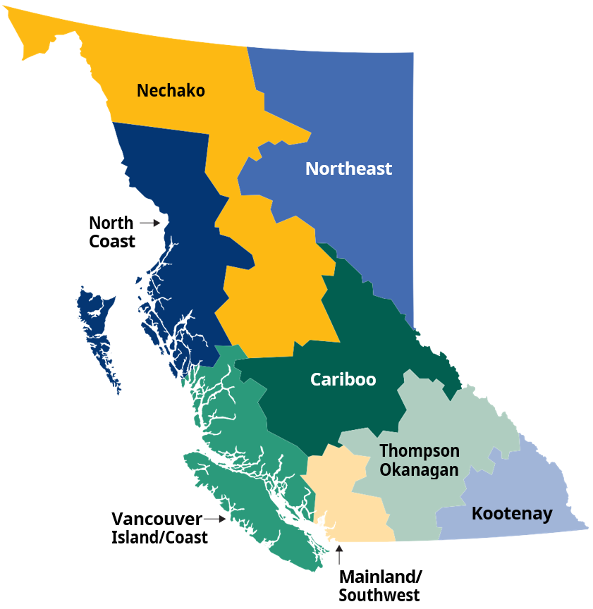
Cariboo
Located in central B.C., the Cariboo region covers much of the northern interior of the province. It covers the Cariboo plateau in the west to the valleys of the Cariboo and Rocky Mountain ranges. It is an area of three worlds: deserts and canyons, evergreen forests, and alpine mountains and glaciers.
Kootenays
The Kootenay region is in the southeast corner of B.C., between the Rocky Mountains, the United States border, and the Thompson Okanagan region. It has clean rivers, lakes, waterfalls, beaches, mineral hot springs, alpine meadows, and snow-capped mountains.
Mainland/Southwest
The Mainland/Southwest region includes the Vancouver area, the Fraser Valley, the Sunshine Coast, and the Sea to Sky Corridor. It includes the Coast Mountain range, river deltas, wetlands, coasts and islands, and lush temperate rainforests. The city centres are near mountains, oceans, lakes, rivers, and beaches. The Vancouver 2010 Olympic and Paralympic Winter Games were held here.
Nechako
The Nechako region stretches from the B.C.–Yukon border in the north down to the central Lakes District of the province. It is separated from the northeastern section of the province by the Rocky Mountain Trench. It is an area of vast and remote wilderness that includes mountains, glaciers, valleys, and plateaus.
North Coast
The North Coast region is beside the Pacific Ocean. It covers the northern coast of the province and the islands of Haida Gwaii. Many species (kinds) of wildlife live in these forests, mountains, and coastlines.
Northeast
The Northeast region shares a border with Alberta and the Yukon and is part of the Peace River Basin. It is separated from the northwestern part of the province by the Rocky Mountain Trench. It's a vast and remote area of mountains, foothills, forests, lakes, and the Peace River valley.
Thompson Okanagan
Located in the interior of B.C., the Thompson-Okanagan region stretches to the Alberta border in the east and the U.S. border in the south. It has Canada’s only desert. It is also home to mountains, rivers and valleys, lakes, dry grasslands, and forested highlands.
Vancouver Island/Coast
The Vancouver Island/Coast region is located on the west coast of B.C. It includes all of Vancouver Island, the Gulf Islands, and some of the coastal regions of the B.C. mainland. In this area, you will find beautiful coastlines, mountains, beaches, ancient rainforests, and agricultural farmland.
B.C. is a large province, and its climate can be very different from one place to another. Generally, temperatures are warmer in the south and colder in the north. There is a lot of rain along the coast.
Seasons
The seasons (winter, spring, summer, and fall) are also very different across B.C. Most of the province has cold winters with low temperatures and snow.
In the southern interior of B.C., summers are hot. In the northern interior, summers are warm.
The coast is different from the interior. The Pacific Ocean keeps temperatures mild in coastal regions. Summers are comfortable, and winters are not as cold as the rest of the province. Being near the ocean means there is lots of rain in the winter. Sometimes, if there is a cold wind from the northern part of Canada, the temperature will drop and the rain will turn to snow.
The mountains also affect the climate. The higher in the mountains you are, the colder the temperature will be.
Summers ( June, July, and August) are hottest in B.C.’s southern interior. In the north and near the coast, summers are mild. You may still want to wear long pants and sweaters in the evenings. Most people wear shorts, short-sleeved shirts, and light dresses in the summer.
Spring (March, April, and May) and fall (September, October, and November) can be warm and pleasant, especially in the south. Daytime temperatures can be warm enough for shorts, short-sleeved shirts, and dresses. But you may need sweaters, long pants, a light jacket, and an umbrella for cool evenings and rainy days.
Winters (December, January, and February) on the coast are mild. If there is snow, it usually melts quickly. On mountains, snow will stay frozen. For winters on the coast, you will need a warm coat, a good raincoat, gloves, boots, and an umbrella.
The interior of B.C. has freezing winter temperatures and lots of snow. You will need a heavy coat, a warm hat, and gloves or mittens.
The north of the province gets longer, more extreme winters. You will need heavy winter clothes and boots.
As of March 2026, B.C. has adopted permanent year-round daylight saving time (DST).
Clocks would usually be turned back on November 1, 2026, but now will remain the same. At that point, the transition to Pacific time (PT), the name of B.C.’s new time zone, will be complete.
Parts of northern B.C. and the Kootenays currently observe different time practices than the rest of the province.
Learn more about this change and the locations that observe mountain time.
Canada has 3 three levels of government:
- federal
- provincial/territorial
- municipal/local
You must be a Canadian citizen to vote in an election for any of these governments.
Federal government
The federal government of Canada is in Ottawa. It creates laws for the entire country and makes decisions over immigration, foreign affairs, and national defence, among other things. The leader of the federal government is called the Prime Minister.
You can get information about the federal government from Service Canada. All information is available in English and French.
Find a Service Canada location near you.
Provinces and territories in Canada have federal electoral districts (ridings). Each riding elects 1 Member of Parliament (MP) to the Government of Canada. There are 42 federal ridings in British Columbia. The MP for each riding has an office in their community. This is called a “constituency office”. You can use your postal code (a part of your mailing address) to contact your MP.
Provincial/territorial government
Canada has 10 provinces and 3 territories. Provincial/territorial governments create laws and make decisions about education and health care, among other things. Sometimes, federal and provincial governments share power. For example, both the federal and provincial governments make laws about agriculture, natural resources, and immigration. The leader of the provincial government is called the Premier.
You can get more information about the Government of British Columbia from Service BC.
There are 87 provincial ridings in British Columbia. Each riding elects 1 Member of the Legislative Assembly (MLA) to represent them. Each MLA has an office in their community. This is called a “constituency office”. Find your riding and MLA.
Municipal/local government
Local governments (municipalities) are cities, towns, villages, and regional districts. There are 188 municipalities and 27 regional districts in British Columbia. Local governments usually manage and provide police services, fire protection, garbage collection, drinking water, wastewater (sewer), recreation (parks and community centres), and library services.
Every local government has an office (usually called city hall or town hall) where anyone can ask questions about local government programs and services. You can also go to the local government office to pay property taxes or get a business licence. The leader of the municipal government is called the Mayor.
Find your municipality or regional district.
Governance in First Nations communities
For thousands of years, First Nations communities organized themselves and solved disagreements in their own way. When Europeans arrived in Canada, they forced foreign systems of governance on First Nations.
Some First Nations communities have agreements with the federal government and provincial government giving them control over their own affairs. This can include making their own laws, deciding how to spend their money, and delivering services within their community.
Some laws are made by the federal government and apply to all of Canada. Other laws are made by provincial governments and apply only to that province.
In Canada, citizenship and immigration laws are decided by the federal government. The federal government also decides on criminal laws (deciding what is a crime and how crimes should be punished).
One of the most important laws in Canada is the Charter of Rights and Freedoms.
The Charter is a federal law that says all Canadians have the right to speak freely, have their own religion, live and work anywhere in Canada, and take part in peaceful political activities.
Provincial governments make laws for their province. This includes laws about natural resources (such as logging and mining) and tenancy (renting a home). Provincial governments also decide most employment laws in their province.
People’s Law School has a guide to laws in British Columbia. It can help you understand your legal rights and responsibilities in daily life. It provides information about working, renting a home, and family relationships.
For more information, download “Learning about the Law" on the People's Law School website.
Cities and towns make laws about things such as streets, parking, and noise. These laws are called “bylaws”.
B.C.’s courts
Different courts deal with different kinds of legal problems. B.C. has 3 main courts:
- The BC Court of Appeal
- The Supreme Court of British Columbia
- The Provincial Court of British Columbia
Find more information on the Provincial Court of British Columbia website.
Canada is a multicultural country. Canadians come from many different countries, and they are proud of their traditions and history. All cultures belong in Canada, and all Canadian citizens are equal.
In Canada, you may find that people speak and behave differently from people in the country you came from. You may not understand why people say or do some things. You may disagree. You may feel confused or embarrassed. You may feel that the other person is not kind or polite.
This might happen because you do not understand Canadian society yet, or because Canadians do not understand yours. This confusion is normal. With time, it will become easier to understand these differences. Try to learn more about Canadian social customs. You can learn by watching how people behave together.
Talk to people, make new friends, and ask questions. Most Canadians will be happy to answer your questions and learn about the customs of your home country. You can also talk with people at your settlement agency.
To find a settlement agency in B.C., visit the links below:
- For permanent residents, including refugees
- For temporary residents, including refugee claimants, temporary foreign workers, and post-secondary international students
Alcohol and cannabis
In B.C., you must be at least 19 years old to buy alcohol or cannabis. You may be asked to show your government-issued photo ID when you buy liquor or cannabis. It is illegal to drive a vehicle after drinking alcohol or using cannabis.
You can only drink alcohol in your own home or certain public places, such as the bar or restaurant where you bought it. Some towns and cities have new laws that allow people to drink alcohol in specific parks or plazas.
Cannabis (marijuana) is legal in Canada. In B.C., you are not allowed to smoke inside public buildings, or near doors and windows. You are also not allowed to use cannabis at playgrounds, sports fields, skate parks, and other places where children play. If you choose to buy cannabis, make sure you are buying it from one of B.C.’s legal, licensed stores. Find legal stores and learn more about B.C.’s cannabis laws.
There are also very strict laws about travelling with cannabis. Make sure to learn the laws before you travel with cannabis.
Being on time
Many Canadians believe it is rude to be late. It is important to be on time for business meetings, personal appointments, or social gatherings. If you are late for professional appointment (such as a doctor’s appointment), you could lose your appointment and may have to pay a fee.
If you cannot arrive on time for an appointment or a meeting, contact the person as soon as possible. Tell them you will be late, or that you need to cancel or reschedule (find a new time for) the appointment.
Some businesses have strict rules for cancelling appointments. This is called a “cancellation policy”. For example, the policy may say you must cancel at least 24 hours before the appointment. If you cancel after this time, they may charge you a fee. Ask about the cancellation policy when you make an appointment.
Etiquette
People in B.C. are generally polite and friendly. Understanding the informal rules for polite behaviour (etiquette) can help you build relationships with people as you settle into life in B.C. Here are some common etiquette rules to know:
- When meeting someone for the first time, it is common to shake their hand and make eye contact. Looking people in the eyes when you speak with them shows that you are paying attention.
- It is common to leave a tip (extra money) for services in restaurants, bars, taxis, and hair salons. The tip for service workers is usually between 10% to 20% of the bill.
- When you are walking on the sidewalk and see another person coming towards you, walk on the right side so they can pass on your left.
- Stand on the right side of an escalator to let others pass on the left. This etiquette is often known as “stand right, pass left”.
- When you open a door, it is polite to hold it open for the people behind you.
- Before you enter a bus, train, building, or elevator, let other people exit first.
- When you have to wait in line (queue), it is important to wait patiently for your turn. You may need to queue to enter a bus or train, to pay for something at the cashier, or to enter a store or a public washroom.
Marriage, divorce, and families
Marriage is a legal agreement between 2 people. In Canada, marriage can also have a religious meaning. Under the law, both people in a marriage are equal. Marriages between 2 men, 2 women, and transgendered people are legal in Canada. Marriage laws apply to everyone who lives in Canada.
Many people want to live together without getting married. This is called a “common- law relationship”. Couples are legally common-law when they have lived together in a marriage-like relationship for at least 2 years. They have the same rights and responsibilities as married couples.
A couple that has a child together and has lived together for less than 2 years is still considered common-law. However, if the couple separates, they are not considered common-law when it comes to dividing property, debt, or pensions.
Canadian law says that you do not have to marry someone, or stay married to them, if you do not want to. You do not need permission from your family or your spouse (the person you are married to) to separate or get divorced.
You do not have to be a Canadian citizen to divorce in Canada. Either partner can apply for a divorce. People in Canada often speak to a lawyer to start a divorce.
Many Canadians are in single-parent families. The children live with their mother or their father. Some children may live with other family members, like grandparents. This may be because the parents have separated or divorced, or because a parent has died. Single parents may marry or have a relationship with another single parent. Both parents and their children may all live together in the same house. These are called “blended families”.
Personal privacy
Canadians usually respect personal privacy. Many people consider it rude to ask someone how much money they earn, what they own, if they are married, who they live with, how old they are, or about their religion or sexual orientation. However, some Canadians are very open about this information. How much people share can depend on whether the conversation is informal (with people they know) or formal (with people they don’t know very well). The best way to learn is to watch how people talk with each other in similar situations.
Personal titles
Canadians are usually informal when speaking with each other. They call friends and colleagues by their first names.
There are traditional titles for men and women. They are used with the person’s last name (for example, Mr. Smith or Ms. Jones). These common titles include:
- Ms. (“Miz”): the title used for women. Some married women prefer to use the title Mrs. (“Missus”)
- Mr. (“Mister”): the title used for men
- Mx: (“Mix” or “Mux”): the gender-neutral title used for both men and women
Using these titles makes assumptions about a person’s gender identity, whether they are married or single, or what they would like to be called. If you are not sure if you should use a title, ask the person what they would prefer to be called. It is not considered rude to ask: “May I call you by your first name, or would you prefer to be called something else?”
Canadians usually use a title when it is part of their work, like “Doctor” (Dr.) for a doctor or dentist, or “Officer” for a police officer.
In some formal situations, such as a job interview or speaking with a customer or a client, you might use a title. If you are filling out a form with your name and address, you may be asked for your title.
Smoking and vaping
You must be 19 years of age and older to buy tobacco (cigarettes, cigars, etc.) and vaping products in British Columbia. It is against the law to smoke in public buildings. This includes office buildings, workplaces, stores, restaurants, and bars. It is also illegal to smoke near doorways, windows or air intakes of public buildings, or on school property. In some communities around B.C., it is against the law to smoke in public spaces such as parks.
Learn more about B.C. smoking and vaping laws.
B.C.’s smoking laws also apply to vaping (using e-cigarettes).
Volunteering
Volunteering is doing work to help others without being paid. Volunteering is an important part of Canadian life. It is a good way to meet new people, learn new skills, get experience, and become part of the community. Most communities welcome volunteers. There are often volunteer opportunities at hospitals, libraries, and community organizations.
If you find an organization you want to help, contact them directly and ask if they need volunteers. Many municipalities have volunteer opportunities. Call or check the website of your city or town.
There are organizations that will connect volunteers with opportunities in their community. Search online or contact your local government to ask if there is a volunteer organization in your town or city.